Miros Oil Spill Detection: Frequently Asked Questions
Miros Oil Spill Detection (OSD) is a world-leading solution for oil spill surveillance and recovery. We asked our team to answer some frequently asked questions about the system.


What is the functionality of the Miros Oil Spill Detection system?
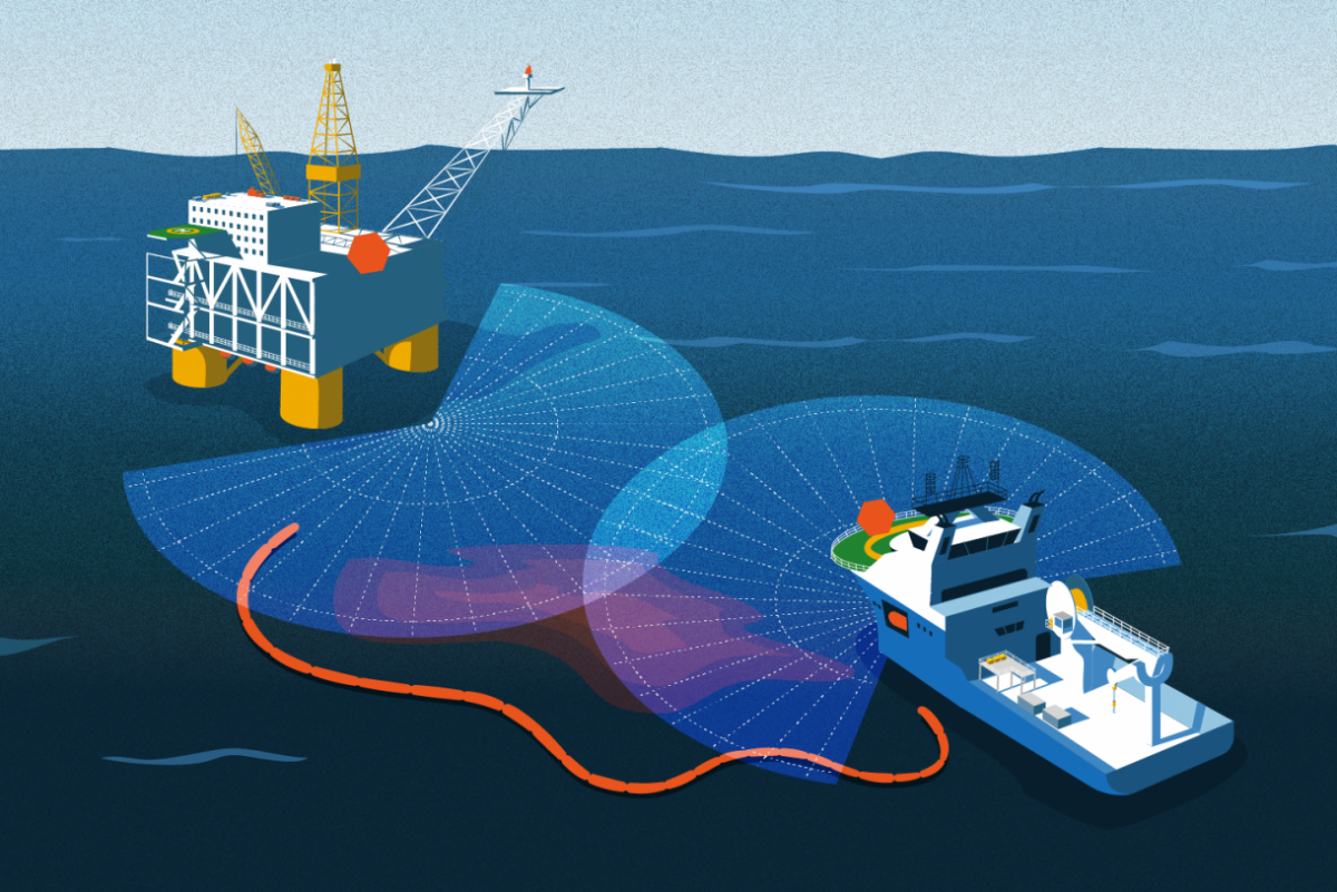
The Miros OSD system offers fully-automatic oil spill detection, without the need for operator intervention. Miros OSD enables continuous surveillance of a large area, making use of data from one or more X-band radar units.
The system can be toggled between two modes, optimised for shifting priorities:
- Surveillance mode provides automatic alarms and situational awareness when an oil spill appears on the ocean surface. The system automatically detects oil spills and shows them alongside AIS targets and infrared (IR)/daylight camera views. Offshore installations and vessels, as well as coastal and port sites, are given early warning capabilities, where real-time data is provided to support response decisions and planning.
- Recovery mode guides response vessels towards the part of the oil slick where the highest recovery efficiency can be obtained. The thickest part of the oil slick is identified with the support of IR and visible spectrum sensors, aiding the correct positioning of booms, skimmers and dispersant.
Miros OSD provides essential insights for any number of simultaneous spills, including oil spill area, position (both predictive and historic) and drift. With additional support options for manual identification using IR and optical cameras, all integrated into a single, intuitive graphical user interface, Miros OSD also offers real-time data export for storage and post-incident analysis.
What is the method of identification employed by Miros OSD?
Miros’ X-band radar-based oil spill detection system makes use of radar backscatter images similarly to methods employed traditionally within navigation, however rather than focusing on areas exhibiting greater amounts of backscatter (objects, vessels, coastlines etc.), Miros OSD focuses on an absence of such backscatter.
The intensity of the reflected radar signal varies based on the structure of the ocean surface from which the reflection is coming. A smooth ocean surface will reflect less energy than a rough surface, such as that produced in the presence of small capillary waves (created by wind). When oil is present on the sea surface it impacts the surface tension of the water and, as a result, wind does not create the same capillary waves on the surface as in areas free of oil. This means areas covered with oil will appear as smooth to the radar and will not exhibit backscatter. Areas free of oil will appear rough to the radar and will therefore exhibit backscatter. The Miros OSD system provides the user with a radar image optimised for visual identification and evaluation of oil spills on the sea surface. In this radar image, areas covered by oil will appear as dark, while areas not covered by oil will appear bright.
How well does the Miros OSD perform?
Very well. Through novel developments, particularly in the function of surveillance mode since 2016, the Miros Oil Spill Detection system combines high sensitivity with a low false alarm rate. With over 200 systems deployed across the globe, Miros OSD is a world-leading solution for oil spill surveillance and recovery. Miros OSD has been verified in tests using crude oil during Norwegian Clean Seas Association (NOFO) annual exercises and has successfully guided recovery efforts during numerous oil spill incidents.
What is the range of Miros OSD?
Typical maximum detection range, depending on antenna height and wind direction:
- 2 – 4 km in short pulse mode
- 4 – 7 km in medium pulse mode
Antenna height: Increasing antenna height increases the grazing angle, which affects the range by increasing the average power at the sea surface. A larger grazing angle also yields a stronger sea echo. Doubling the antenna height will typically increase the range about 18-25%, depending on slick properties such as size and homogeneity.
Wind direction: Upwind is more favorable than crosswind or downwind. An exception to this rule is in the case of a land site where the wind blows from inland, where only minor waves are created within a short fetch. In this scenario a good range would be expected downwind.
Typical camera range depending on camera installation height and atmospheric conditions:
- 0.9 – 6 km
What external sensors does the OSD system interface with?
Miros OSD makes use of one or more X-band radars. The system also utilises data from an AIS receiver and a wind sensor, and for a moving installation requires GPS and gyro compass (or similar).
Can the Miros OSD system determine the location of the highest concentration of oil?
The Miros OSD system, at its most comprehensive, aggregates data from radar, infrared and optical sensors into a single, intuitive user interface. Simply speaking, the radar sensor provides spill detection and tracking, the infrared sensor allows for relative thickness estimation as well as spill recovery in darkness (or low visibility), but it is through the addition of an optical sensor that the Bonn Agreement Oil Appearance Code (BAOAC) can be applied in order to connect visual assessment to thickness estimation.
How is Miros OSD affected by weather conditions and low visibility?
A wind speed of at least 2 m/s is required for sufficient radar backscatter from the ocean surface. Miros OSD is unaffected by lighting and visibility conditions. Heavy precipitation may affect sensitivity. IR camera range may be affected by humidity, water temperature, as well as oil and solar irradience.
Is Miros OSD suitable for use on vessels, does it have built-in motion compensation?
Yes, Miros OSD comes with built-in motion compensation and is suitable for use on vessels.
Can the system predict the trajectory of an oil spill?
Yes it can, based on measured wind and current conditions.
Is it possible to use the system to record the evolution of the oil spill trajectory?
Miros OSD’s graphical user interface can show up to 24 hours of oil spill history. The most recent spill data is shown in yellow, with historical spill data shown in shades of purple. Spills are displayed with the most recent spill data on top, making it is possible to intuitively visualise and understand the movement of any spills.
Historical oil spills are logged according to their geo-referred position. The data history playback feature supports playing back processed radar image data. Raw data may be stored for later post-processing.
Can the system provide an estimate of the spill area, with real-time distance measurements to a defined point?
Yes, it can.
Can Miros OSD measure slick area, thickness and volume?
Miros OSD calculates the area of a spill and displays this to users. Spill thickness estimation is made possible with the addition of visual and IR cameras. It’s a relation between thickness and oil color properties in the visual domain established by Bonn Agreement oil Appearance Code (called BAOAC). It is then possible to enter a thickness estimate for volume calculations.
Can the Miros OSD system leverage an AIS system to detect vessels in the vicinity of the oil spill?
Yes, Miros OSD can interface with an AIS receiver via standard AIS NMEA sentences.
How quickly can Miros OSD detect an oil spill on water?
Once a suspicious phenomenon is flagged, the system tracks its development over time. Miros OSD will signal that oil has been detected within 5-10 minutes of reaching the surface of the sea within the area under surveillance.
What is the minimum area and volume of oil Miros OSD can identify?
- Minimum detectable area is 10,000 m²
- Maximum detectable area 1 – 2 km²
- Minimum detectable thickness is 1 micrometre
Is the mapping continuous, or sectioned into time frames?
The mapping of the oil spill is continuous. Automatic detections are updated every minute, BSI image on every scan.
Does Miros OSD supply information on currents and winds at the location of an oil spill?
Current data is generated from Wavex, which is an optional add-on to the Miros OSD system. The radar needs to be run in short pulse mode in order to provide data on current. A wind sensor is also required. Miros can provide a wind sensor if no such sensor is available on site.
Regardless of the addition of Wavex, the drift of the spill is generated and reported upon. Wind, oil drift and current are provided in the graphical user interface.
How easy is it to share data from the Miros OSD system with relevant stakeholders, on- and offshore?
The customer is fully in control of access to the system and with whom they share data from the system. You can configure how data can be shared within your own company network or via FTP connections.